Tanjung Pinang |
|
||
Indonesia - 2012 |
|
|
|
|
|
|
|
|
Our intend to sail down from Singapore to Belitung, then out through Sunda Strait, which separates Sumatra from Java, placing us on the "southern route" to South Africa. After an intial beat to Belitung, we should enjoy beam or downwind sailing, though it may be a rowdy and wet trip. Our southern route includes passing by the infamous Krakatau, on to Cocos Keeling, then to Chagos, Rodriguez, Mauritius, Reunion, arriving in Richards Bay, South Africa, before November. At least that's the plan... Today we rolled our air conditioner down the dock to its new owner, and said goodbye to Singapore. A heavy downpour delayed us, but soon skies cleared and we cast off. We bobbed around in the Western Quarantine area to clear immigration. A boat came by to take papers and stamp our passports, and we were underway. We played Frogger across the double lanes of freighter traffic, crossing to the Indonesian side. Our engine is overheating slightly. Dave suspects the raw water pump, and will swap it out. By mid-afternoon we approached Nongsa Point. The marina sent out a skiff to guide us in through the reef cut, though it is marked. The marina agent climbed aboard, took our papers and passports, and $50 USD, and we are cleared in. Our CAIT is here, so all the official bits are done. Could not have been easier. We are tied up next to Estrellita, who gave us local knowledge. They arrived 2 days ago and scoped everything out. Our plan is to follow them into every anchorage all the way to South Africa.
|
|
|
|
|
|
I rode the marina shuttle to the Mega Mall and got SIM cards for phone and internet, bobbed in the pool and did laundry while Dave tried to track down our engine overheating problem. He's checked every element of the raw water side, and removed the thermostat, then went over the side with the hookah to scrape Baraka's bum. Lots of barnacles from sitting several months in marinas. He found a new problem in the engine exhaust elbow, and is trying to track a replacement in Singapore, but so far no joy. The clock is ticking on our CAIT. We can spend a few days here, but must move along soon, as our cruising permit and visas will expire at the end of June.
|
|
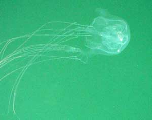
Box Jelly.
|
Dave used the hookah to clean thru-hull fittings and scrub the bottom. He was nearly done when I noticed a sea snake just yards from the boat. He sprang out of the water. A few days later Amy noticed this equally deadly critter pulsing along the docks at Nongsa. Hmmm.
|
|
|
|
|
In resolving our engine overheating problem, Dave took apart and examined
every bit of the raw water cooling side. In doing so, he found a new issue - a hole
inside the exhaust mixer elbow. This hole is not a show stopper - at least right now. But we are reluctant to begin a long season of passage-making with a known problem. The part isn't available on Batam or in Singapore, but he located it in the states, and tonight (daytime on the east coast of the US) will arrange shipping to Singapore, and then transport here to Batam. So we will stay here another few days, perhaps a week, waiting for the part. It is tricky to assess readiness. Looking at boat systems, we could find another dozen problems. For the next 4 months it will be difficult or impossible to get parts. At some point, we must decide we are "ready enough" and just go, assuming we have adequate spares and skills to get us to South Africa. Meanwhile the clock is ticking on our Indonesian cruising permit and visas. We must clear out of Belitung, 4 days distance away, by the end of June. So it's an exercise in risk assessment - at what point do you have enough information to make the right decision? One cruising boat we know spent 4 years in port trying to get everything right.
|
|
Exhaust fittings - the culprit aluminim elbow is to the left.
|
Once Dave took the enhaust apart he could see that the mixing elbow's inner core had holes burnt clear through both sides, from the hot engine water input. Glad he is thorough enough to discover this problem before it becomes a crisis, and we are lucky to find it now, where a replacement can be readily obtained.
|
|
|
|
|
The exhaust elbow made it to Singapore in just 2 days, and then another day
across to Nongsa, with a helpful guy from Keppel Bay. Thanks, Munir!
Dave borrowed Estrellita's propane torch and got our old elbow
apart, then installed the new one. This morning we took on 378 liters of
diesel, paid up our bill, got port clearance and set off from Nongsa Point.
The boat and crew are happy to finally be underway! Around the corner of
Batam we got light winds on the nose. Soon we could fall off for Bintan and
coast along under main and jib for a few hours, sweet! We are headed to
Tanjung Pinang, up a little estuary, hoping to do a some exploring, then
will work our way south in the wakes of Estrellita and Taipan. Dave asks whether it feels like we're on our way home. Today does feel significant somehow, a turning point for us. We both are relieved that all the preparation is behind. We are a cruising boat again.
|
|
|
|
|
|
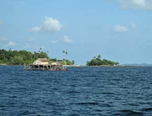
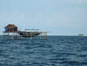
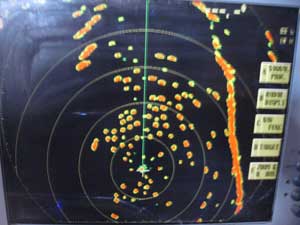
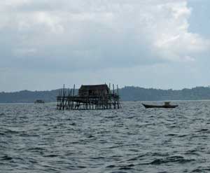
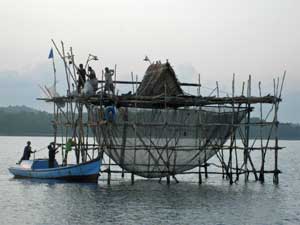
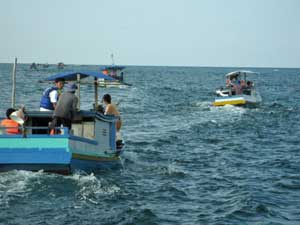
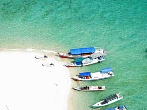
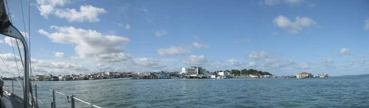
Tanjung Pinang on Pulua Bintan was fascinating. We followed the high-speed ferries up a channel, then anchored around the bend at 0 degrees 56.1856 N 104 26.4425 E. All night boat traffic bustled around us, mosquito-fleet ferries from the town to the stilt village across the river, tankers, percussive one-cylinder fish boats, and rusty, listing freighters being unloaded by hand into a raft of dugouts. Fun just sitting in the cockpit watching the show. Wished we could stay to explore a couple days, but felt we must move along. So the next morning we motor-sailed, an easy trip to Mesanak, anchored 0 26.0459 N 104 31.1790 E, a little rolly but not bad. Another boat found the shoal and spent the day aground. Chart coverage is inconsistant. Our CMAP charts barely show the reef, though the Navionics charts on the iPad are great, excellent detail. We are using the computer for most navigation, but the iPad is proving very handy in the cockpit as we enter and leave anchorages. Tonight we are anchored at Kentar, having come down along the east side of Sebangka through hundreds of fish camps on stilts, each in 40-50 feet of water, with a huge hanging net and good-sized banana-leaf house. Amazing to see them in such deep water. We turned into Kentar 0 03.216 N 104 45.547 E, coming in the "back door" from the west side over the south tip of a shoal with no problems. The anchorage here is flat calm, very protected - and we may opt to park here a bit. Strong winds are forecast from the south for a couple days. No point in beating into it. All is well - the engine repairs are solid, and it is running at the right temp. The captain/chief engineer is happy.
|
|
Anchorage at Mesenak.
|
Cool stilted fishcamps on way to Kentar...
|
The radar shows hundreds of them.
|
Each has a suspended net and a thatched house.
|
|
|
|
|
We are bashing SSE along Bangka, on our way to Belitung, still a day away. This is why cruising boats hate to go to weather! 10-12 knots on the nose. Seas are moderate, the bigger waves arrest our progress forward. Best we can do is about 4 knots, burning through fuel and racking up engine hours. Baraka is motor-sailing just off the wind enough to partially fill a reefed main and staysail. Yesterday we sailed through 2 squall lines. The first, during daylight, peaked at 30 knots, just when I was considering "scandalizing the main" - a nautical term from Uncle Carson. The second came at night, with plenty of warning to toss a reef into the main. These show up beautifully on our radar, helping us steer to minimize impact. This morning we took a wave into a hatch I forgot to dog down, water sloshing on the fore cabin floor. Dave has a short list of broken things (oil engine pressure gauge light dead, outside bottom instrument bad readings…) but nothing critical. Ahead are numerous karangs - shoals - dotting the sea like evil germ colonies in a Petri dish. We will tack our way through them, hoping they are all charted. The gribs show more of the same weather for 4 days, about what we expected, so we are carrying on, hoping to make Belitung tomorrow if this gets no worse. After Belitung we can turn to a better angle and sail.
|
|
|
|
|
|
Our second night out, more than halfway, the engine started temp started creeping up. We could manage it for awhile, running at lower rpm to cool it, but by 11 pm, were losing that battle, and decided to run back to the sheltered anchorage at the north end of Bangka, at 1 degree 30.5936S 105 52.4507E, arriving after dawn. We shut the engine down and sailed back, giving up some hard-won miles, but happy to have made the right decision. This morning Dave fired up the genset to chill the fridge, and it immediately overheated, too! Totally unrelated, as the genset and engine have completely independent cooling systems. We sailed all the way into the anchorage, only starting the engine the final bit, to set the anchor. Estrellita was already here. There’s a refreshing breeze, and a small bouncing motion, but excellent shelter. At anchor, Dave took the genset raw water pump off, finding the impeller in fragments, ears broken off, an easy fix as he has the spares needed. After a nap he’ll tackle the engine. Today we heard from another boat working south that they hit a reef along Bangka, breaking the steering chain. They sailed back to their last anchorage to repair. Except for some scratches and frayed nerves, they are fine. We are glad to be in contact with others making this trip. Things do go wrong, and it is reassuring to know others are within reach if help is needed.
|
|
|
|
|
|
Once the genset was fixed, Dave worked on the engine, swapping out the raw water pump for a spare, working until 9 at night. He’s tired - had to do all that on top of 2 night’s passage. I am sure few people work as hard as he does. Is this "retirement"? I checked the weather and it looked favorable to go sooner rather than later, so after a quiet night at anchor we got away early, and now, 8 hours later, are almost to where we were when we turned back. The engine is running cool, yay! All is well.
|
|
|
|
|
|
With the engine running cool, and the weather holding, we made it to the NW corner of Belitung, hook down at 2 33.4145 S, 107 38.3624 E, the anchorage recommended by Harun Cahyadi. We initially tried the Sail Indonesia rally anchorage around the corner, but upon arrival the winds oddly clocked from the NE in a small squall, so this option was more sheltered. Good to be quietly at anchor again. OK passage overall, though we motor-sailed the whole way, a bash to weather. From here to Mauritius winds should be aft the beam. The motor will get a good rest. We will stay here 5 or 6 days, doing laundry, taking on fuel and fresh produce, and rigging Baraka for ocean passage-making. We have a long list of offshore prep tasks, different from coastal cruising. We’ll mount the windvane paddle and run its lines, secure anchors, deflate the dinghy and lash it down, run jacklines and set out safety gear. There is internet here, via a cellular modem. That is a luxury soon to end - from here on we will not have internet, and email only via Sailmail on our HF radio. Time to start watching weather for the next leg, down Sunda Strait to Cocos Keeling. Next weekend may be a favorable start, with smaller tide changes meaning less turbulence in the strait, and a full moon.
|
|
|
|
|
|
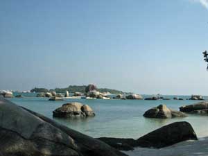
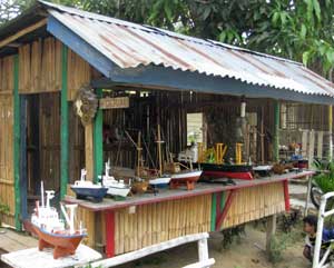
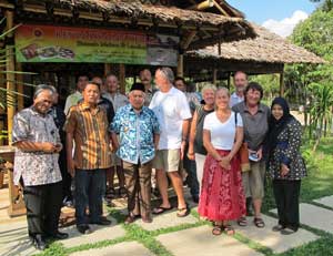
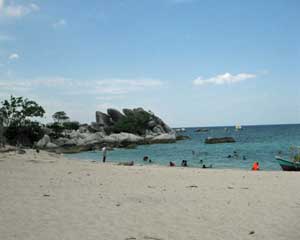
What a great place! We were made very welcome by Mr. Harun Cahyadi, who greeted us ashore, and showed us where to park our dinghy. We discussed our needs, for laundry, propane, diesel, petrol, groceries, port clearances, and filling a scuba tank. Harun is a busy young entrepreneur with a business barging sand to Java, and is interested in creating a marina for cruising yachts on the west side of Belitung. As far as we know, Indonesia only has the dicey and tiny Benoa marina on Bali, and Nongsa Point, just across from Singapore. Indonesia is a fascinating cruising ground, and more boats would linger at pretty Belitung if there were facilities here. Belitung is strategically situated, on the Sail Indonesia Rally path, with boats converging from Java and Kalimantan, and also, increasingly, with boats headed SE from Singapore, taking the southern route across the Indian Ocean to avoid Red Sea piracy. Harun took us to a close-by casual beachfront restaurant for a tasty seafood meal, then gave us a tour to an ATM machine, parks, the city center, a good grocery, a fruit stall, and a final stop for coffee and sunset-watching at classy Bahamas Hotel. He will arrange a driver and car for us to run our errands this week. We are anchored near Langkuas Lighthouse, which we hope to climb. Tomorrow we will re-anchor closer to shore to make it easier to load fuel. This area is gorgeous - lovely granite boulder formations resembling Stonehenge, ringed by white sand beaches, clear waters, and an interesting fishing fleet. Some of the fishing boats have outriggers both sides, quite wide away from the boat, to suspend a single net below to catch small fish and squid. Each evening they parade to sea, drop their net and shine bright lights, bobbing on the horizon, and returning in the morning.
|
|
Exploded Genset impeller.
|
6 men harvest their net at Kentar.
|
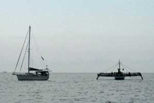
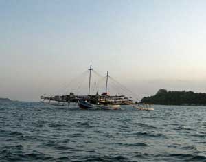
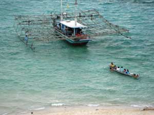
Outrigger fishing boat passes Estrellita.
|
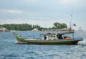
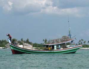
Indonesia boats are colorfully painted.
|
|
|
|
|
Yesterday Dave joined Estrellita and Taipan, and escorted by Harun, made the rounds of Port Captain, Customs, Immigration, Quarantine. The local officials handle the Sail Indonesia rally boats, but this is a bit different so we are all feeling our way. So far they have been most accommodating, and Harun's assistance has been invaluable. Dave is documenting the procedure for the boats following in our wake. Harun is bringing jugs of solar (diesel) to Mr. Memed's beach for us. We took the dinghy and sounded a closer-in anchorage, then moved the boats in to make jugging the diesel easier. We are now anchored at 2 33.4824 S, 107 38.9479 E, on sand in 23 feet of water at low tide. There is a reef patch behind us, clearly visible at noon, but otherwise the way in was quite straightforward, and this anchorage is super calm. We have a new boat equipment problem: the rubber coating on the coiled HF radio microphone wire is peeling off, exposing the tiny wires. Oddly, rubber disintegrates on boats in the tropics. For example, rubber bands soon go brittle. Dave is concerned the wires inside may break, and he can't fix the 10-wire plug end. I ordered a new mike from eBay, to be delivered to Cocos Keeling. We are going to go through Internet Withdrawal when we leave here!
|
|
Mr. Harun Cahyadi makes our stop at Belitung a delight.
|
|
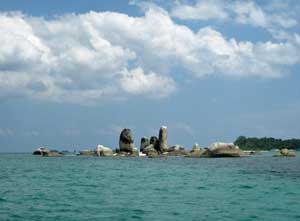
Granite boulders were tossed to Belitung, possibly by Krakatau.
|
Muslim families have a beach outing.
|
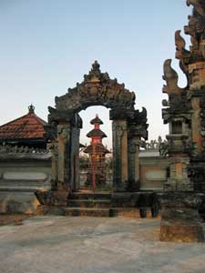
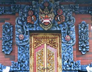
Some years ago the government sponsored relocation of some Balinese to Belitung...
|
...bringing their distinctive temple art.
|
A Barong guards to doorway.
|
Harun treats us to coffee at his Uncle's place.
|
The view from Mr. Memed's beach.
|
Belitung ships.
|
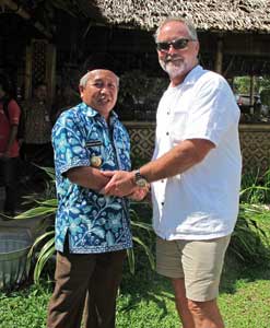
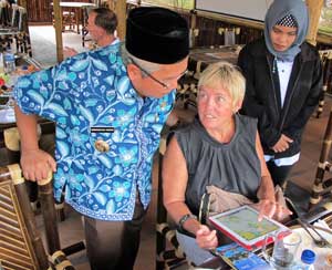
Belitung's Western Regent graciously meets with us.
|
Kris shows him our anchorage on her iPad.
|
We felt honored by this meeting.
|
Mr. Harun Cahyadi arranged for us to meet with the Western Belitung Regent and his staff, and with the head of the Belitung Tourism office to discuss tourism opportunities for cruising boats. With the Red Sea effectively closed, many more boats will be returning to Indonesia, and to lovely Belitung. We could not have felt more welcome, and appreciated these important people taking time to meet with us.
|
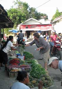
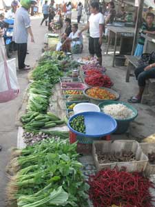
We go to the afternoon market...
|
...for abundant fresh vegetables.
|
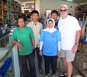
Harun's sister has a great hardware store.
|
Outrigger boats parade through our anchorage.
|
We are an item on the tour boats agenda.
|
xxxxxxxx
|
Stonehenge of the East.
|
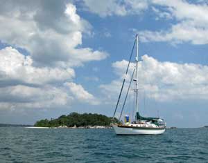
A spectacular anchorage.
|
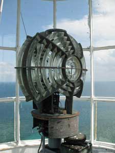
We dinghy to Langkuas Lighthouse...
|
built by the Dutch in 1888.
|
xxxxxxxxxxx
|
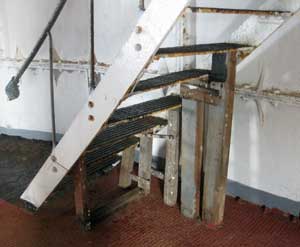
Rusted stairs are supported by timbers.
|
Outriggers bring tourists to visit the lighthouse.
|
We make it to the top.
|
Far below our dinghies wait.
|
The lovely fresnel lens has been replaced by LEDs.
|
|
|
|
|
Baraka is anchored at a small island just west of Belitung, at 2 59.227 S 107 13.662 E. This morning we started with a lovely sail. By afternoon the winds built to the point where we reefed down (after taking a splash through the main hatch, salt spray on the computer keyboard) and finally had to motor-sail into 18-20 knots. When we arrived at Pulau Aur, Estrellita was already anchored. We dropped our hook just starboard of them, near a small pier. Yikes! We were suddenly swept over reef. Dave backed out and I pulled the anchor up. So we worked to their port, and had a similar fire drill when I suddenly saw reef off the bow I could have stood on. We backed into deeper water, anchoring in 55', drifting back to 75', and all is well. We are here just overnight, to help us time the currents at Sunda Strait.
|
|
|
|
|
|
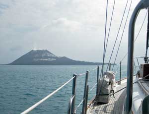
Our anchorage at Aur CANNOT be recommended. Though we enjoyed a calm night, we were aghast when we woke and saw the reef extending all around at low tide, including between us and open water! Baraka escaped unscathed, and got some 20-knot winds and lumpy seas for a fast sail. Overnight both wind and seas moderated. We happily sailed toward Sunda Strait, which separates Java from Sumatra. Skirting extensive oilfields, we worked toward the Sumatra side. Huge oil platforms loomed, easy to see and avoid. Several large squalls gave brief whiteouts. Estrellita reported seeing 30-knots and waterspouts. We wanted to hit the strait middle of the night with a favorable current, and though we slowed down, favorable winds pushed us earlier than planned - about an hour after slack water at 6 pm. Sunda has only 2 current changes a day, though there are normal tide changes 4 times a day. There seems little correlation between tides and currents. By the strait, we were again within visual sight of Estrellita. We worked across the ferry lanes, and dodged a couple freighters. Traffic was manageable. In the area between Pulau Sangiang and Tanjung Tua, current turbulence kicked into high gear. Our speed impeller read 2 knots through the water, while GPS showed us making 6-8 knots over the bottom. Huge breaking swells buried our bow. We dropped the companionway hatchboards in, and Dave handed me my harness, though the cockpit stayed dry. For a half hour we crashed along, decks awash, then the seas moderated to a hobby-horse rocking. The current carried us to Krakatau.With SSW winds of 12-14 knots, we chose the southern anchorage at Pulua Rakata. Moonlight helped, though we never saw the big circular reef. Dave slowly motored Baraka against the cliffside, hugging the steep-to shore, inside where charts placed the reef. The depth sounder could not find bottom until we were near our anchorage. Reluctantly, Dave and I discussed giving up, and carrying on to Cocos Keeling. Finally we found 80 feet, then 60, and dropped the hook at 6 08.6830 S, 105 25.6347 E in 65', near a couple fishing boats and a sailboat. 2 am, we opened a bottle of chilled white wine, and celebrated with brie and crackers in the cockpit, looking over at smoking Anak ("child of") Krakatau in the moonlight. Very cool!!! This morning we can see just how closely we are snuggled to shore, with its skinny fringe of black sand beach below a vertical wall of jungle. We are embraced by the caldera rim, very protected, in one of the most dramatic settings of our voyage. The caldera is 6 miles across, comprised of 3 curved islands, with Anak in the center. Anak Krakatau has its own smoking crater, and is coated with white ash that looks like snow. We will park here a day to enjoy the view, and hope for a good weather window for the 5-day jump to Cocos Keeling.
|
|
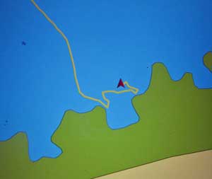
Yikes! The chartplotter shows we nearly kissed the reefs.
|
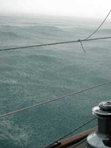
Whiteout squalls on the way to Sunda pound the seas flat.
|
|
|
|
|
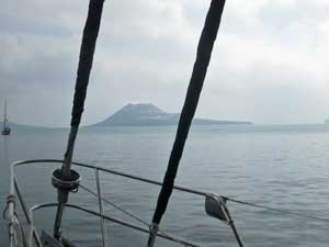
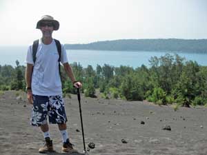
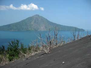
Krakatau last famously blew in 1883, decimating the Sumatra and Java coastlines. Britain experienced measurable waves! The explosions were heard as far away as Rodriguez and Western Australia, and the world enjoyed blood red sunsets for several years. Anak beckoned, so we moved the boat to the ranger station, 6 06.009 S, 105 25.984 E, anchoring in 60' off the black sand beach. Estrellita pumped up their dinghy and rowed ashore with Dave. The park rangers sort of arbitrarily took a combination of rupiah, Singapore and American dollars, then escorted them through the brush to the base of Anak, with emphatic instructions not to climb beyond the big ridge. Dave said the sand there was hotter below the surface. Smoke curled out of the sides, but there were no explosions or big belches. Back at the beach Dave collected a small souvenir sample of fine black sand for me, and we moved the boats back to the more sheltered southern anchorage for another quiet night. We may stay one more night, to do laundry and rebuild the head, pink jobs aboard Baraka, enjoying this magical place. How often can you anchor inside a caldera and watch a baby volcano grow?
|
|
Anak "child" Krakatau.
|
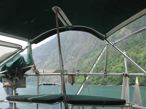
At anchor, we are embraced by the caldera rim.
|
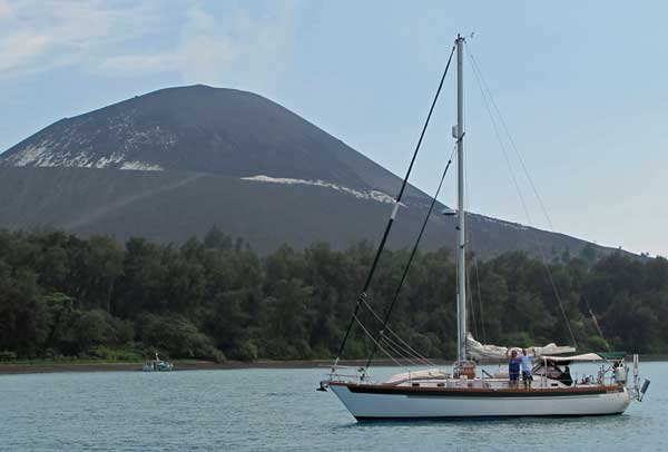
Baraka anchored at Anak "child" Krakatau.
|
|
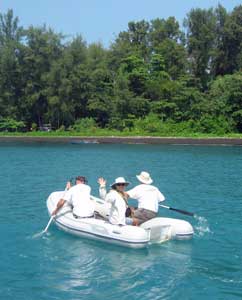
Rowing ashore to climb Anak.
|
|
From the ridge of Anak Krakatau.
|
Anak ominously smokes.
|
Click here for our Singapore 2012 journal. |
|
|
© Copyright 2012. All Rights Reserved. |
|